- Home

- Blog
- Tom Parker
- Weed mapping
Weed mapping

Weed mapping has been around, in various guises, for some time. For example, it might be in real-time by identifying weeds in the field and directing a spray nozzle during application. Or it could be based upon creating maps of weed infestations ahead of application.
Application technology will get more accurate and, if we allow our minds to wander forward a few decades, who knows what might result? For now though, it's better to think about what we can achieve today and what the advantages are for us in doing so.
What are the benefits to weed mapping?
There are economic, agronomic and environmental benefits associated with reducing weed infestation through the use of mapping techniques.
The reduction of seed return must always be our goal with difficult grassweeds. At a recent Frontier 3DThinking research seminar my colleague and fellow blogger David Robinson shared this staggering fact: the number of seeds returned within two rotations by leaving one black-grass plant uncontrolled in an oilseed rape crop is 40,000.
40,000! It is definitely a numbers game and mapping can help manage those numbers.
Where do you start
The first step is to establish where our weeds are. This can be done in a number of ways:
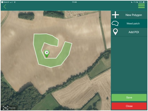
- By physically mapping weeds in the field using iSOYLscout – the scouting app allows users to map by drawing, GPS tracing, or simply photographing weeds in the field. This could be pre-harvest when weeds are apparent within a crop (black-grass or brome) or earlier in the year, post drilling.
- Drone or aerial images can be used to pinpoint where weed populations are. This data can be used by mapping biomass and 'ground-truthing' it to identify weeds, or by automatic algorithms that recognise the spectral signatures (specific wavelengths of light) which highlight weeds.
- Lastly, weeds can be drawn in mySOYL. This is useful when your knowledge of your land tells you where infestations are or if they are prevalent on particular soil types. mySOYL helps to define them for you to plan targeted applications. It can also be useful to make sure other people, such as contractors, target application in the right place.
Below is a screenshot of capturing a weed area using iSOYLscout:
Weeds can also be identified from aerial images utilising advanced identification techniques:
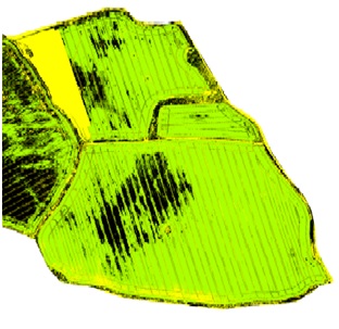
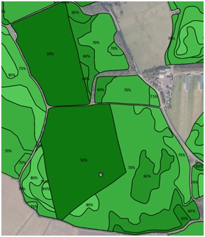
Once your problem areas have been identified, the next step is to use this information to determine where additional attention is required. This is achieved by using the data within mySOYL to produce a VR application plan. As an example, the weeds in the aerial image above are clearly identifiable.
It is a very simple but very well informed output directing increased control measures where required.
Of course, control will not be achieved in one season and weeds don't tend to move around. Therefore, the same control geometry might be used for an autumn herbicide as well as pre-harvest glyphosate in some cases – you derive value multiple times.
Benefits
The insight above means you are also able to take advantage of other methods of control. For this example, the same information can be used to change the establishment of the seed plan to offer competitive control from the crop itself. This is achieved by lowering the plant establishment in these areas, thereby increasing the number of crop plants. The same process can also be achieved using iSOYLscout observations, all through mySOYL.
Maps may also help you to identify water courses and design your application plan in accordance with buffer zone restrictions, as well as help with stubble management and where best to target stale seedbed efforts.
Mapping can identify areas to spray off pre harvest to reduce seed-return in the worst affected areas.Mapped black-grass areas could also be used to pin point underlying issues causing patches of weed infestation. For instance, where there are drainage or soil compaction issues that require remedial attention.
Additionally, mapping can be a useful check after a standard in-field herbicide programme to measure the efficacy of the treatments applied. This can identify areas of potential resistance that require further investigation and action.
The benefits of mapping to help manage troublesome weeds are significant and the use of mapping to do this is something we are developing and refining all the time.

Tom Parker
Head of products and technology
As a subscriber, you’ll receive email alerts each time a new blog is published so you can always stay updated with the latest advice and insights from our experts
Comments